 About Culebra About Culebra
Geography, Flora, Fauna, Climate and some of Culebra's History
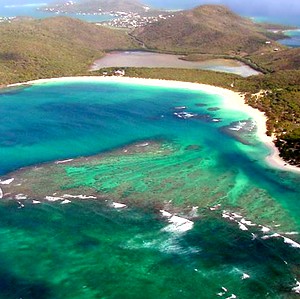
Culebra's series of bays, peninsulas, and bars create a long and intricate shoreline, some of which end in abrupt cliffs, sandy shores, or mangrove forests. The principal harbor, Ensenada Honda, is considered to be one of the most secure hurricane harbors in the Caribbean. The topography of Culebra is irregular with low elevation hills. Mount Resaca is the tallest hill on the island at 650 ft.
Location
The island of Culebra lies approximately 17 miles east of Puerto Rico, 12 miles west of St. Thomas and 9 miles north of Vieques. Its total area, including surrounding cays, is 7,000 acres
The weather is usually Perfect :)
|